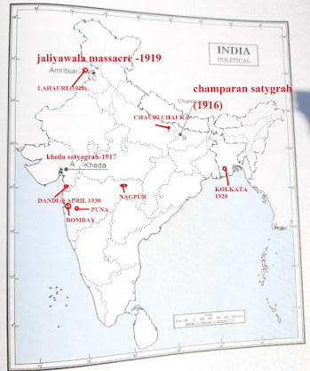
Map work of Class 10 & 12
1. On the political outline map of India some coal fields, nuclear power plants and thermal power plants are shown.
भारत के राजनीतिक रूपरेखा मानचित्र पर कुछ कोयला क्षेत्र, परमाणु ऊर्जा संयंत्र और थर्मल पावर प्लांट दिखाए गए हैं।
 |
| Power plants & Coal fields |
भारत के दिए गए राजनीतिक रूपरेखा मानचित्र पर कुछ लौह अयस्क और तेल क्षेत्र
 |
| iron ore & oil field |
I-Iron and steel plants
C-cotton textile centres
W-woollen textile centres
S-silk textile centres
5. SOFTWARE PARK IN INDIA
 |
| Iron & textile industry |
4. On the political outline map of India ,some highways shown the names of terminal cities marked A,B,C,D,E,F,G & H
 |
| HIGHWAYS |
 |
| SOFTWARE PARK |


No comments:
Post a Comment
M. PRASAD
Contact No. 7004813669
VISIT: https://www.historyonline.co.in
मैं इस ब्लॉग का संस्थापक और एक पेशेवर ब्लॉगर हूं। यहाँ पर मैं नियमित रूप से अपने पाठकों के लिए उपयोगी और मददगार जानकारी शेयर करती हूं। Please Subscribe & Share